Geospy AI: So far, you must have learned to perform a reverse image search, which helps identify whose image it is, and if it’s available on the internet, it becomes open. But today, we will teach you how to determine the location where the image was taken and the background behind it through the image. We will also learn about the type of clothing and jewelry worn in the image. All this information will be provided to you by the Geospy AI tool.
Using Geospy AI, you can determine the location of an image by uploading it, including the country, state, district, and providing a description. It also provides you with the exact coordinates of where the photo was taken. Therefore, stay connected with us until the end to learn more about the Geospy tool and how to use it effectively.
What is GeoSpy AI?
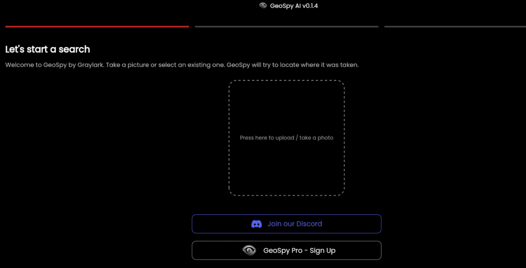
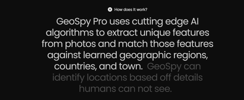
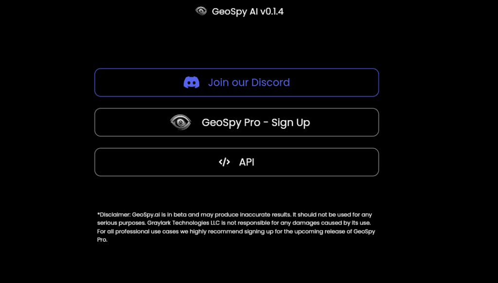
Geospy is an AI tool where you can upload an image to determine its geo-location, as well as easily identify the clothing and jewelry worn in that photo. You can also use this tool on a Discord server. The Geospy AI app is currently running on v0.1.4, which will continue to improve in the future.
By using GeoSpy AI download, you can remember the correct location of your old photos or any other photo. Additionally, you can explore the background of a photo and visit that place. Therefore, stay connected with us until the end to gather all the information about Geospy.
Read this also:- Groq AI vs Chat Gpt [ Best Ai Model in 2024 ]
Geospy AI Login:
- First, you need to go to the official website geospy.ai. Then you will see the option for Geospy Pro. Click on it.
- After that, you need to enter a working email. You will be notified as soon as this option is open.
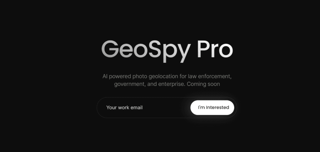
- Currently, there is no login option, as this is a new website, but soon all its features will start working gradually. Therefore, you can use it without logging in.
Read this also:- Otter AI: Best AI Meeting Assistant Tool in 2024
How does GeoSpy AI Work?
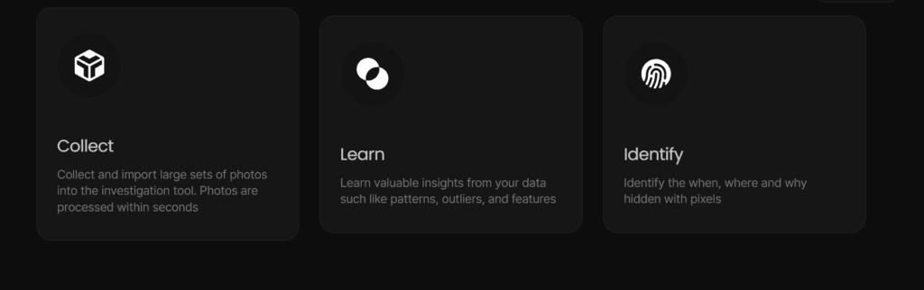
Utilizing GeoSpy AI is a straightforward process:
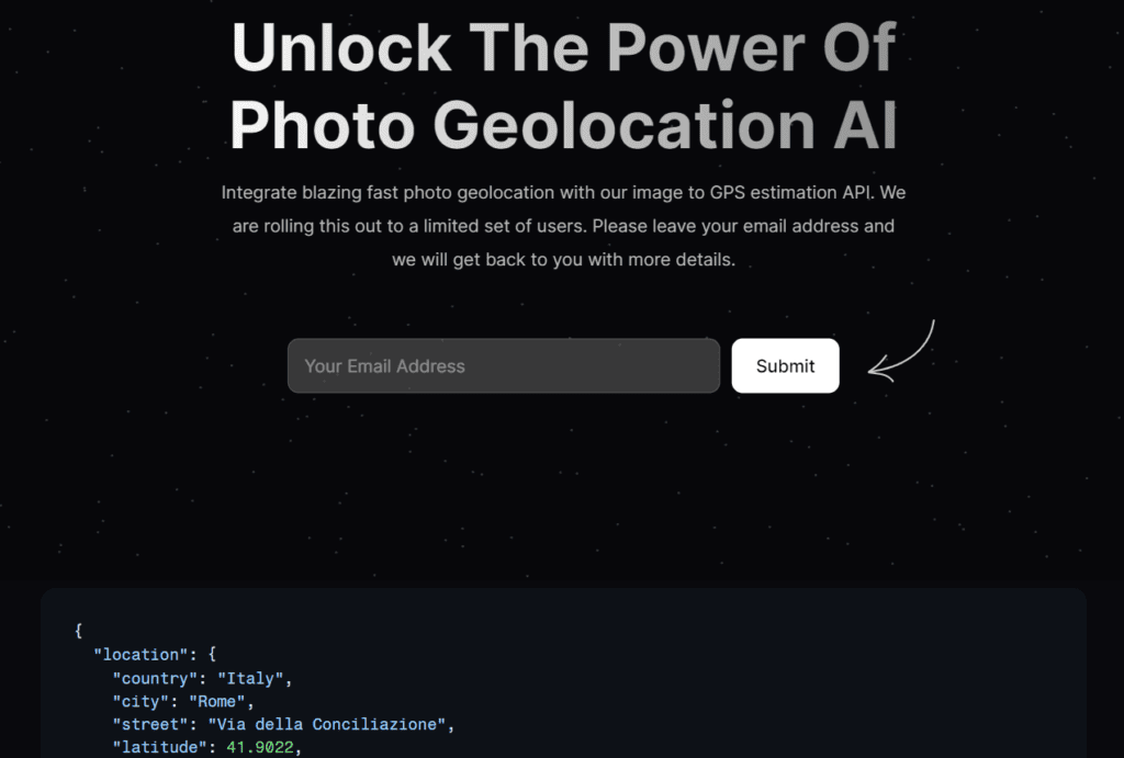
- Visit the official GeoSpy AI website where you’ll find the option to “Press here to upload/take a photo.”
- Upload the desired photo and provide any relevant information about it.
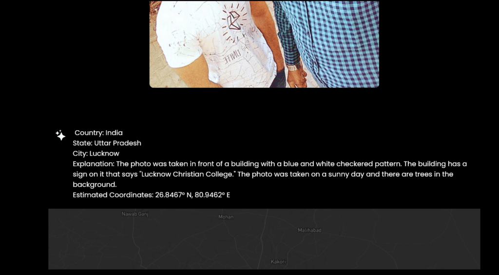
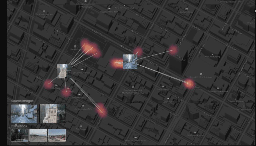
- GeoSpy AI download will then provide details such as the country, state, city, explanation, and coordinates associated with the image.
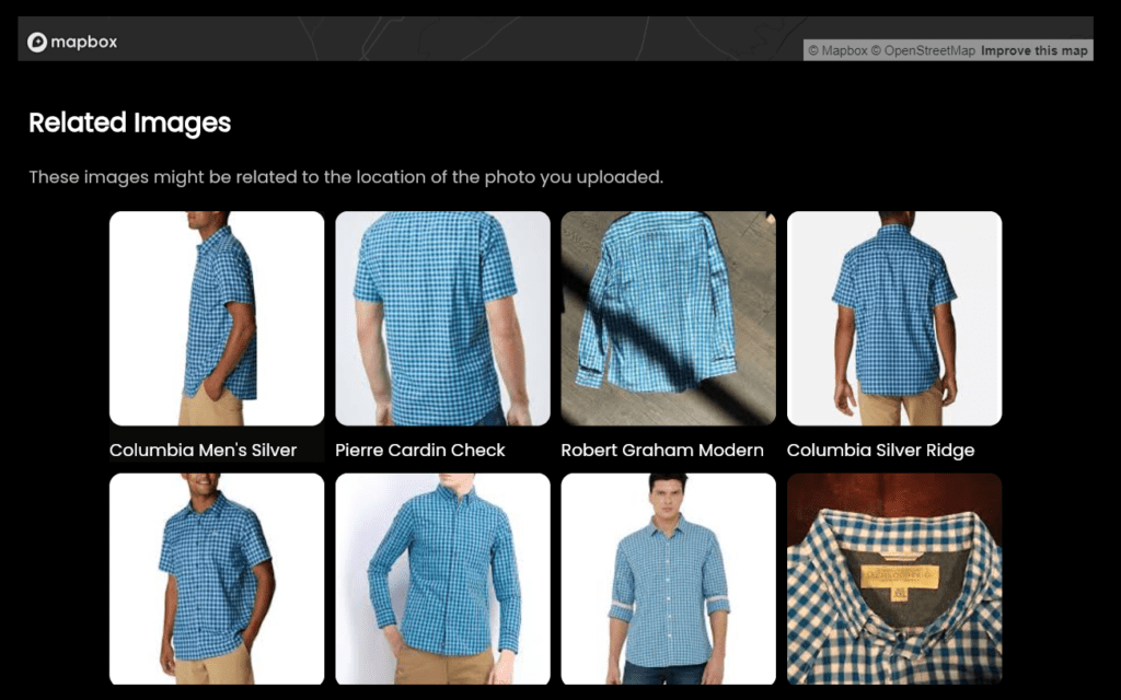
- Additionally, related Google images linked to the uploaded image will be accessible, allowing users to further examine clothing and accessories.
Read this also:- invideo AI Studio: Text to Video Generator Tool
GeoSpy AI Features:
GeoSpy AI offers several notable features:
- Image to location tool: Users can determine the location depicted in an image.
- No login required: Access GeoSpy AI’s functionalities without the need for a login.
- Free of charge: GeoSpy AI is entirely free to use.
- Future prospects: A pro version of GeoSpy AI is anticipated, offering login capabilities and subscription options. Until then, users can enjoy the free version.
- Detailed insights: GeoSpy AI app enables users to identify the location, attire, and accessories depicted in an image.
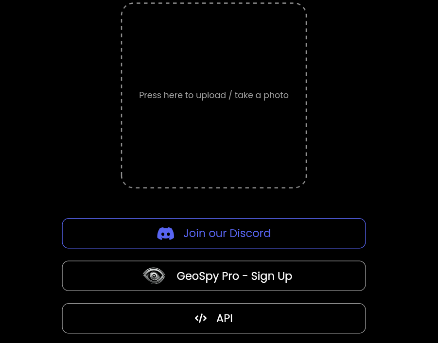
- API availability: GeoSpy.AI provides an API for further integration and customization.
- Reverse Image Search: Users can perform reverse image searches to find similar or identical images on the internet. This feature is particularly useful for verifying the authenticity of images or locating their original source.
- Contextual Background Information: In addition to geolocation data, GeoSpy AI provides contextual background information about the location where the image was taken. This may include historical facts, notable landmarks, or cultural information related to the area.
- Image Metadata Extraction: GeoSpy AI image extracts metadata embedded within the image file, including details such as the camera model, exposure settings, and timestamps. This metadata can offer insights into the camera equipment used and the circumstances surrounding the image capture.
- Social Media Integration: Users can connect GeoSpy AI tool to their social media accounts to analyze images directly from their social media feeds. This integration enables seamless image analysis and enhances user convenience.
- Custom Solutions and APIs: GeoSpy AI offers custom solutions and APIs for businesses or organizations with specific image analysis needs. These customized solutions can be tailored to extract specific types of information or integrate with existing systems.
- Enhanced Accuracy and Performance: GeoSpyAI continually improves its algorithms and performance to deliver more accurate and reliable results. As the tool evolves, users can expect enhanced accuracy in geolocation analysis and image recognition capabilities.
- User Privacy Protection: GeoSpyAI prioritizes user privacy and data security, ensuring that uploaded images are not used for any unauthorized purposes. The tool adheres to strict privacy policies and safeguards user data against misuse.
- Real-Time Image Analysis: GeoSpyAI allows users to analyze images in real-time, providing instant feedback and insights. This feature is beneficial for situations where quick decisions or actions are required based on image data.
Here is my latest article! A deep dive into @heinenbros & @GrayLark_io GeoSpyAI! Thanks to Daniel for taking the time to answer questions featured in this article!https://t.co/Ie6UmeQwn1
— Caden (@osintcaden) January 22, 2024
- Multi-Language Support: GeoSpyAI supports multiple languages, making it accessible to users worldwide. Language support enhances user experience and ensures that individuals from diverse linguistic backgrounds can utilize the tool effectively.
Happy to see #GeoSpy is being used to fight fake news. https://t.co/9VVphqagkH
— Graylark.io (@GrayLark_io) February 3, 2024
- Image Enhancement Tools: GeoSpyAI includes image enhancement tools that improve the quality and clarity of uploaded images. These tools can adjust brightness, contrast, and other parameters to enhance visual details and facilitate more accurate analysis.
- Collaborative Image Analysis: Users can collaborate with colleagues or team members by sharing analyzed images and insights within the GeoSpy AI platform. Collaborative features facilitate teamwork, knowledge sharing, and decision-making based on collective input.
A new version of https://t.co/yyG0qXj4py (@GrayLark_io) was released today – GeoSpy AI v0.1.4.
In addition to coordinates and a map, a list of similar images is now also displayed to help to pinpoint location more accurately.
(links to other AI #geoint tools in comment) pic.twitter.com/7ad7x2lLld
— Cyber Detective💙💛 (@cyb_detective) February 14, 2024
- Integration with External Platforms: GeoSpyAI offers seamless integration with external platforms and applications, allowing users to incorporate image analysis functionalities into their existing workflows. Integration options enhance productivity and streamline image analysis processes.
- Advanced Search Filters: GeoSpyAI provides advanced search filters that allow users to refine their image analysis queries based on specific criteria such as date, location, or image attributes. These filters enable users to pinpoint relevant information more effectively.
New Update 🚀 BETA
We have added the ability for #GeoSpy to find property listings based on the structures detected in an image. This update will help with finding more precise locations in rural and city environments. pic.twitter.com/EFafYOIXeV— Graylark.io (@GrayLark_io) February 18, 2024
- Customizable Reporting: Users can generate customizable reports based on image analysis results obtained from GeoSpy.AI. Reports can be tailored to include specific data points, visualizations, and insights, catering to the unique requirements of users or organizations.
- Machine Learning Capabilities: GeoSpy.AI leverages machine learning algorithms to continuously improve its analysis capabilities and accuracy over time. Machine learning enables the tool to learn from user interactions and data patterns, resulting in more intelligent and precise image analysis.
Read this also:- Sora AI: Open Ai Text to High Quality Video Generator Tool in 2024
GeoSpy AI API:
For those interested in accessing GeoSpy AI’s API, visit the official website and navigate to the API section. Enter your working email ID, and the company will reach out to provide access to the API.
GeoSpy AI Review:
My experience with GeoSpy AI has been highly satisfactory. While traditional image search methods through platforms like Google offer insights into online images, GeoSpy AI takes it a step further by providing location-specific details and contextual information. While not 100% accurate, GeoSpy AI consistently delivers precise country and state identifications. With anticipated enhancements in the pipeline, GeoSpy AI is poised to become even more refined. In the meantime, users can make the most of its free version.
Read this also:- Soundhound AI Inc: Transform Your Businesses with Advanced Voice AI Solutions in 2024
Conclusion:
The conclusion is that Geospy does not engage in any activities that could compromise the privacy of user images. It maintains the privacy of the images uploaded by users and ensures that their experience is not negatively affected. If you desire more articles like this or have suggestions for new tools, you can contact us. Simply comment with the name of the new tool you’d like us to write about, and we’ll provide an article on it the next day. Until then, you can read our other articles. Thank you.